'Available at your nearest Ordnance Survey map stockist', index maps gave details of current map availability, their sheet lines and the progress of the map's publication. Usually free*, they were often discarded or buried deep in a collector's 'archive'. Sometimes found among the odd 'n' sods in second-hand book and charity shops, index maps are a fruitful, if curious, corner of OS map appreciation.
Immediately after the conclusion of the Second World War, the Survey pressed on with the work to build the peace. This included an index map using the (by then standard) scale base map of 1:625,000, for the 'two-and-a half inch to the mile' map series (1:25,000). This was followed by indexes using pre-war base mapping - of 1:2,000,000 & 1:1,250,000 scales - for the other small scale sheets in production.
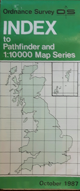
In about 1960 the Survey began to produce indexes to accompany the developing 1:25,000 ('Pathfinder') and other emerging leisure map series. This single sheet map was reduced in scale to 1:1,000,000 in the mid 1970s (with a few exceptions), and by 1990 had become a double-sided 1:625,000 map folded in integral Bender covers for stockist display.
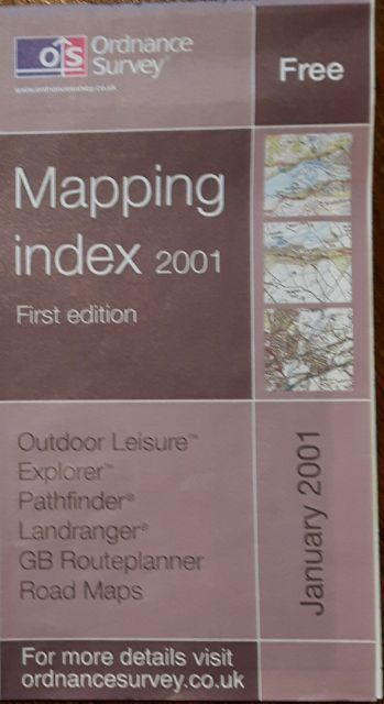
In 2001 the 'one-size-fits-all' version changed scale again to 1:800,000 before being discontinued the following year. This marked the end of Index sheets in favour of Index Mapping leaflets which include sheet line images of the various series avaiable.
* Athough two 1:250,000 scale maps published in 1946 were priced at 2/-.
PLEASE NOTE I have the occasional enquiry through these pages about whether I buy and sell maps. I'm not a map dealer but here to compile and revise lists of Ordnance Survey small scale maps. If you are looking for a trader, I recommend you start with the Charles Close Society list of map dealers here.
{ } References to sections in Ordnance Survey Small-scale Maps, Indexes : 1801-1998 Roger Hellyer, Kerry, 1999.
1:2,000,000 Scale
Indexes at this scale utilised pre-war base mapping, hastily produced in the period during the Survey's recovery. They were published as a flat sheet and priced 6d.
Index to the Ordnance Survey of England & Wales, overprinted in red with Scale: One Inch to One Mile, New Popular Edition 1938.
Print-code : 3246/A
Ordnance Survey of Great Britain, overprinted in blue with Index to Sheets of the Quarter-Inch Fifth Series, 1955
Print-code : 4270 C
Index to 1:25,000 Series
Print-code : 3952 770 Ordnance Survey 1955. Amended to 1st Jan. 1958.
Index to sheets of the Half Inch Second Series
Print-code : 3952 Ordnance Survey 1955. No other date. [Accession stamp 2.2.1959]
Index to sheets of the Quarter Inch Series Fourth Edition / Index to sheets of the Fifth Quarter Inch Series
Print-code : 3952 Ordnance Survey 1955. Amended to August 1959.
1:1,250,000 Scale
Index to the New Popular, 5th Edition and Popular Edition One Inch Maps, 1946 {§114 4.1}
Print-code : 3993. Price : 2/-. Probably not published but printed in 1949.
Index to the Popular, New Popular and 7th Series One Inch Maps of Great Britain, 1946 {§114 4.2}
Print-code : 3794. Price : 2/-. Printed 20.11.52
Index to the 1:50,000 Sheet Lines, 1971-72 {§114 4.3}
C Printed 2.4.71
D Printed 26.4.72
Index to the 1:50 000 Scale Map, 1974 {§114 4.4}
DC Printed 2.4.74
National Grid Index to 1:25,000 Sheets, 1946 {§89 B1.29}
Print-code : 50046. Printed 11.45
Index to ... Maps at Scale of 1:25,000 (about 2½ Inches to the Mile) on National Grid Lines, 1954 {§89 B1.30}
Print-code : 768 Printed 1954
Print-code : 769 Printed 1954
Map Index 2001. Cover : Mauve with white title in purple panel. Published January 2001. Map Index 2001 v2. Cover : Light blue with title in darker blue panel. Published July 2001. Map Index 2002. Cover : Aqua blue with white title. Published May 2002. Map Index 2003-4. Cover : Aqua blue with white title. Published June 2003. Print-code : OPT 46496_0303. Map Index 2004 and order form. Print-code : D01820a 0903. Map Index 2004. Cover : Aqua blue with white title. Print-code : D031930 1003. Map Index 2004 / Mynegai mapiau. Cover : Aqua blue with white title. Print-code : D01820a 0204. Map Index 2005. Cover : Mauve with white title. Print-code : D02883a 1204. Map Index 2005 / Mynegai mapiau. Cover : Mauve with white title. Print-code : D02883aw 0205. Map Index 2006. Cover : Mauve with white title. Published 13.3.06. Print-code : D03860 0106. Map Index 2006 / Mynegai mapiau. Cover : Mauve with white title. Published 31.5.06. Print-code : D03860w 0206. Map Index 2007. Cover : Mauve with white title. Published 15.1.07. Print-codes : D04876a 1106 and 0307. Map Index 2007 / Mynegai mapiau. Published 31.5.06 (apparently). Print-code : D04876w 0207. Map Index 2008. Cover : Mauve with white title. Published 29.2.08. Print-code : D05711a 1208. Map Index 2009. Published 16.3.09. Print-code : D06295a 1208 Map Index [2010]. Cover : Mauve with white title. Published 21.1.10. Print-code : D07340_01 1209. Map Index 2011. Probably not published. Map Index 2012. Published 11.5.12. Print-code : D09345_02 0412.
1:625,000 Scale - main maps (Landranger & Explorer)
Map Index [2013]. Cover : Light gray with purple title. Published 16.9.13. Print-code : D10664_01_0613. Map Index 2014. Probably not published. Map Index [2015]. Cover : Blue with white title. Published 22.6.15. Print-code : D12840_e_0215. Map Index [2015] v2. Cover : Blue with white title. Published 7.9.15. Print-code : D12840_e_[????]. Map Index [2016]. Cover : Pale cream map graphic with grey title. Published 18.5.16. Print-code : D12840_e_0216. Current edition
Some miscellaneous items - leaflets containing indexes
Major upgrade of 1:25 000 scale mapping
A5 format. Print-code : DS 20264 0996.
Pathfinder maps to be phased out ... Explorer maps and Outdoor Leisure will take their place
DL format. Issue One, Summer 1997. Print-code : DS 20437 0697.
Outdoor Leisure and Explorer maps. Pathfinder maps to be phased out...
DL format. Issue Two. Spring 1998. Print-code : DS 20437 0298.
DL format. Issue Three. Spring 1999. Print-code : DS 20437 1098.
DL format. Issue Four. Summer 1999. No print-code
Index of Explorer maps. Including Outdoor Leisure maps.
DL format. [Issue Five.] Spring 2000. Print-code : DS 20437 0200.
Your access to the countryside. Explorer and Outdoor Leisure maps upgrade programme
DL format. [Issue Six. Spring 2001.] Print-code : DS 20437 1100.
... and so on until March 2003.
The Lez Watson Inexperience
The author - Leslie (Lez) V Watson - has asserted his right under the Copyright, Designs and Patents Act, 1988, to be identified as the author of this work. I use Visual Studio Code & Notepad++ script editors, and Firefox web browser. ♣ 10.15 :: March 2026